Crişul Pietros
The navigable upstream end is between the Ape (confluence Boga Valley – Galbena Valley) having an altitude of aprox. 550m, and the downstram end is at Pietroasa having an altitude of 400m.
The cover distance on water: 8km
Estimated time: 2-2,5 hours
The period in which the flow is navigable: April, May and in the rainy periods. It is approachable with kayaks and rafting boats (only when the level of the water is high and at high floods)
Difficulty level: III-IV alternative on the way, IV at high floods
Access to the upstream end: from the national road DN76/E79 from Sudrigiu turn right to Pietroasa, then turn right to the holiday village Boga until you get to Ape.
Other observations: In Spring and sometimes at high floods appear trunks on the river bed. On the upstream way it is recommended to make a recognition of the route (can be made from the car) to identify the trunk parts.
Accommodation possibilities: camping, chalets, private pensions.
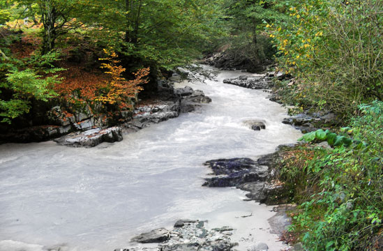
Crişul Repede
The navigable upstream end is at Bulz at the altitude of aprox. 350m and the downstram end is at Vadu Crisului having an altitude of aprox. 270m.
The cover distance on water: 25km
Estimated time: 4-5 hours
The period in which the flow is navigable: March – May, but also in the rainy periods. It is approachable with kayaks, canoes and rafting boats
Difficulty level: I-II alternative on the way, III- IV at high floods.
Access to the upstream end: from the DN1(E60) after Piatra Craiului follow the road to Bulz and passthrough Stana de Vale flag station.
Other observations: open valley including the Pass. Pay attention to the obstacles from the Bratca dam: steel cables, concrete pillars with the reinforcings exposed etc, from the center of Suncuius commune and to the bridge`s ruines after the Vadu Crisului Waterfall at the Pass exit.
Accommodation: private pensions.
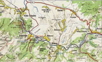
Vadu Crisului - Bulz Map
click to enlarge
|